Deriving Phytoplankton community composition from optics and remote sensing (2022)
Phytoplankton sustain the base of aquatic food webs, influence biogeochemical cycles, and account for approximately half of global primary production. I am interested in developing methods to estimate phytoplankton community composition in coastal waters using a combination of in situ and remote sensing data. I am currently collecting optical measurements of inherent optical properties (phytoplankton pigments, non-algal properties, and chromophoric dissolved organic matter) to use in algorithm development for detecting phytoplankton taxonomic and functional groups. This work will be validated using phytoplankton pigment concentrations from High Performance Liquid Chromatography (HPLC) and phytoplankton taxonomic information using an Imaging Flow Cytobot (IFCB). This work will focus on hyperspectral remote sensing reflectance data in anticipation of NASA’s Plankton, Aerosols, and Ocean Ecosystems (PACE) mission.
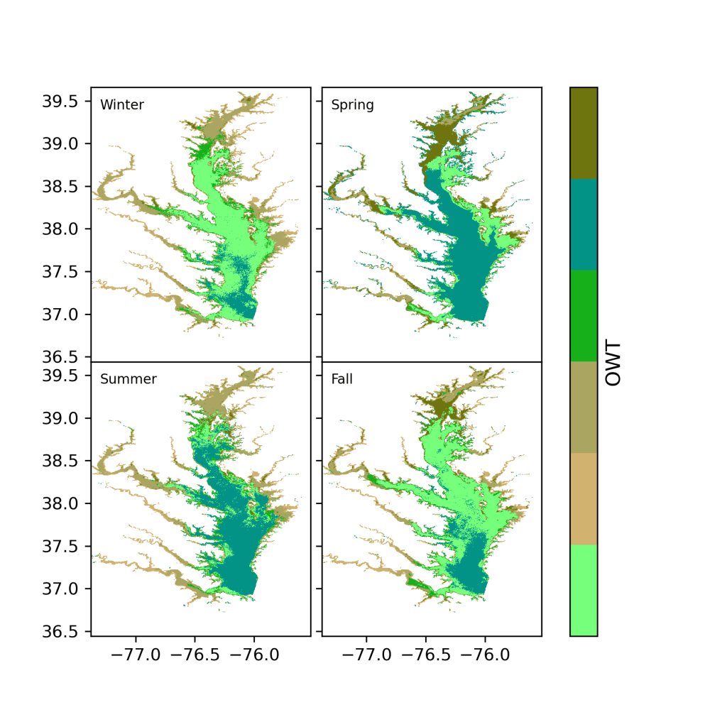
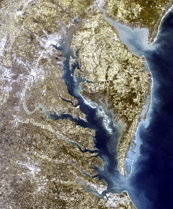
Optical water type classification of chesapeake Bay (2022-2023)
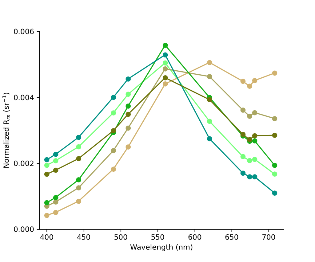
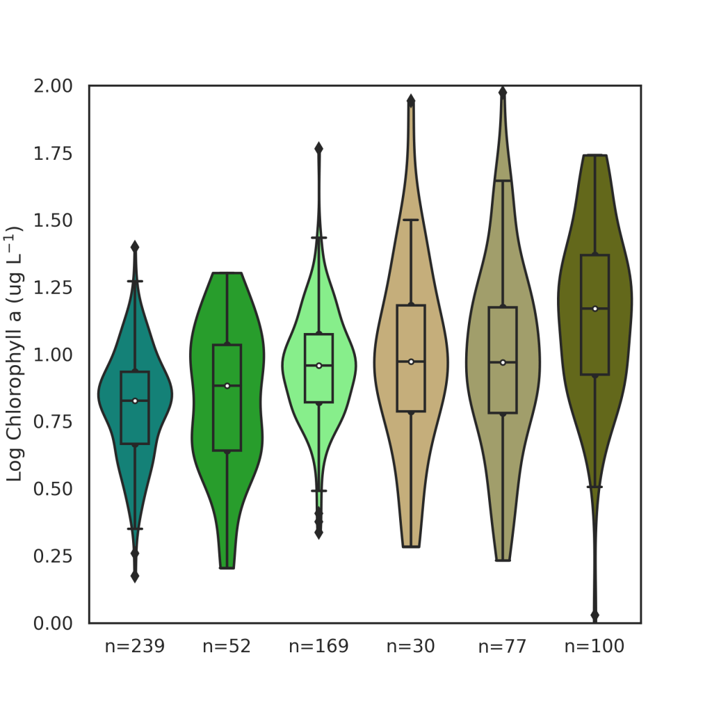
Remote sensing reflectance (Rrs) spectra is the fundamental quantity derived from ocean color satellites and used as input into various bio-optical algorithms to obtain of water quality concentrations such as chlorophyll a. An optical water type classification defines dominant Rrs spectra through space and time and can be used assess marine biological diversity of different water bodies and aid in bio-optical algorithm selection. The objective of this research is to build upon the knowledge of optics in Chesapeake Bay and describe optical water types over time and space. This research will be used to investigate if water quality properties (Chl a, inorganic suspended sediments) are constrained within optical water types. We ran an unsupervised machine learning clustering algorithm (K-means) to 51 million Rrs spectra collected by the Ocean Land and Color instrument onboard the European Commission Copernicus programmes Sentinel 3A and 3B to derive dominant Rrs spectra, or optical water types, of Chesapeake Bay.
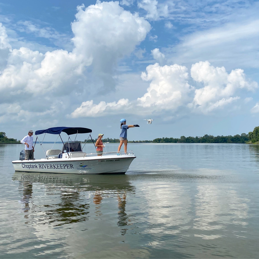
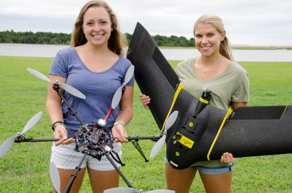
multispectral drone remote sensing can assist in water quality in monitoring coastal waters (2020-2022)
Unoccupied aircraft systems (UAS, or drones) equipped with off-the-shelf multispectral sensors originally designed for terrestrial applications can be used to derive water quality properties with improved spatial and temporal resolution that is needed to monitor rapidly changing environments such as an estuary. Failure to accurately account for surface reflected light can significantly influence remote sensing reflectance, resulting in inaccurate water quality estimates once algorithms are applied. The objective of this research is to evaluate the efficacy of methods that remove surface reflected light from total UAS radiance measurements in order to derive accurate remote sensing reflectance retrievals and scientifically valuable in-water constituents. More information can be found in this StoryMap.
Publications:
Windle, A. E., & Silsbe, G. M. (2021). Evaluation of unoccupied aircraft system (UAS) remote sensing reflectance retrievals for water quality monitoring in coastal waters. Frontiers in Environmental Science, 9, 182, doi:10.3389/fenvs.2021.674247
Gray, P. C., Windle, A. E., Dale, J., Savelyev, I. B., Johnson, Z. I., Silsbe, G. M., Larsen, G.D. & Johnston, D. W. (2022). Robust ocean color from drones: Viewing geometry, sky reflection removal, uncertainty analysis, and a survey of the Gulf Stream front. Limnology and Oceanography: Methods, 20(10), 656-673. doi:10.1002/lom3.10511

The Use of drone imagery for tidal wetland vegetation monitoring: a case study at poplar island, md (2019-2023)
Tidal wetlands, existing at the nexus of land and water, are amongst the most vulnerable environments to climate and anthropogenic change. Environmental monitoring is critical to assess and better understand the fate of extant and restored tidal wetlands. High resolution drone imagery provides the temporal and spatial scales needed to study critical processes such as wetland vegetation changes. I have conducted drone flights with a multispectral sensor over a restored wetland cell at the Paul S. Sarbanes Ecosystem Restoration Project at Poplar Island. Wetland vegetation classification maps were compared to as-built planting plans to delineate instances of significant marsh migration.


Publications:
Windle, A.E., Staver, L., Elmore, A.J., Scherer, S., Keller, S., Malmgren, B. and Silsbe, G.M., Multitemporal high-resolution marsh vegetation mapping using Unoccupied Aircraft System remote sensing and machine learning. (2023). Frontiers in Remote Sensing, 4, doi:10.3389/frsen.2023.1140999
Evaluation of Atmospheric Correction Algorithms Applied to OLCI Sentinel-3 Data in Chesapeake Bay Waters (2019-2022)
Satellite remote sensing permits large-scale monitoring of coastal waters through synoptic measurements of water-leaving radiance that can be scaled to relevant water quality metrics and in turn help inform local and regional responses to a variety of stressors. As both the incident and water-leaving radiance are affected by interactions with the intervening atmosphere, the process of atmospheric correction essential to derive accurate water-leaving radiometry. In this study, a regional in situ dataset from the Chesapeake Bay was used to evaluate the performance of four atmospheric correction algorithms applied to data collected by the Ocean Land Color Instrument (OLCI) to identify the best performing atmospheric algorithm algorithm for Chesapeake Bay. This research aims to improve remote sensing of coastal waters and advance water quality monitoring and management in Chesapeake Bay. I presented this research at the 2020 Ocean Sciences Meeting.
Publications:
Windle, A. E., Evers-King, H., Loveday, B. R., Ondrusek, M., & Silsbe, G. M. (2022). Evaluating Atmospheric Correction Algorithms Applied to OLCI Sentinel-3 Data of Chesapeake Bay Waters. Remote Sensing, 14(8), 1881, doi:10.3390/rs14081881

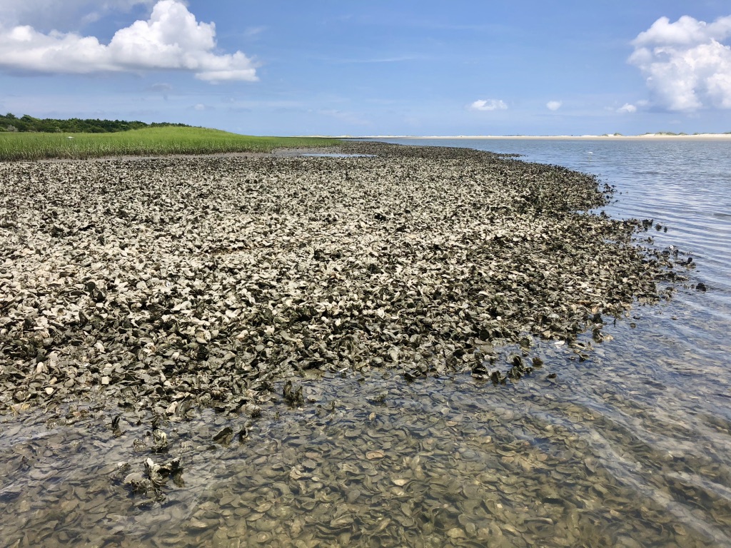
Using Unoccupied Aerial Systems (UAS) remote sensing to monitor intertidal oyster reef habitat (2017-2020)
Funded through North Carolina Sea Grant/Space Grant, we researched how to effectively monitor intertidal oyster reef habitat using unoccupied aircraft systems (UAS, or drones). We used a variety of different UAS aircraft and sensors to assess oyster reef condition. By analyzing UAS imagery, we were able to nondestructively estimate critical oyster reef metrics such as reef area and height. More information can be found on this interactive ESRI story map.

Publications:
Windle, A. E., Puckett, B., Huebert, K. B., Knorek, Z., Johnston, D. W., & Ridge, J. T. (2022). Estimation of Intertidal Oyster Reef Density Using Spectral and Structural Characteristics Derived from Unoccupied Aircraft Systems and Structure from Motion Photogrammetry. Remote Sensing, 14(9), 2163, doi:10.3390/rs14092163
Ridge, J. T., Gray, P. C., Windle, A. E., & Johnston, D. W. (2020). Deep learning for coastal resource conservation: automating detection of shellfish reefs. Remote Sensing in Ecology and Conservation, 6(4), 431-440, doi:10.1002/rse2.134
Windle, A. E., Poulin, S. K., Johnston, D. W., & Ridge, J. T. (2019). Rapid and Accurate Monitoring of Intertidal Oyster Reef Habitat Using Unoccupied Aircraft Systems and Structure from Motion. Remote Sensing, 11(20), 2394, doi:10.3390/rs11202394
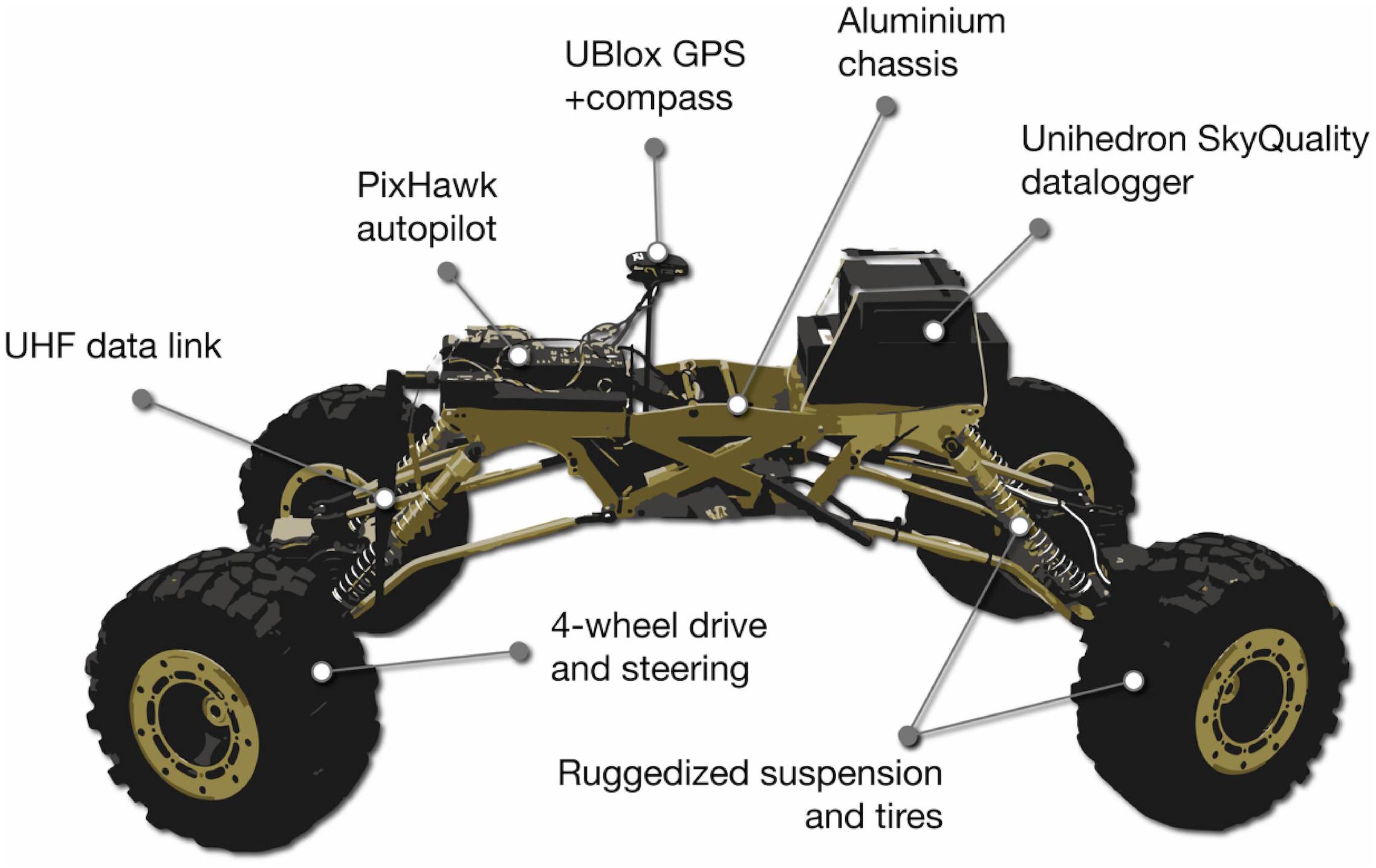
Autonomous terrestrial rovers enable high resolution light pollution sampling at sea turtle nesting beaches (2017-2018)
For my Master’s Project at the Nicholas School of Environment at Duke University, I used a terrestrial rover to quantify artificial nighttime light, or light pollution, on beaches in North Carolina. I compared light pollution measurements to sea turtle nesting trends to study the effect on female nest site selection and hatchling orientation. I concluded that there were fewer nests occurring in areas of high light pollution. I presented this research at the North Carolina Museum of Natural Sciences.

Publications:
Windle, A. E., Hooley, D. S., & Johnston, D. W. (2018). Robotic vehicles enable high-resolution light pollution sampling of sea turtle nesting beaches. Frontiers in Marine Science, 5, 493, doi:10.3389/fmars.2018.00493
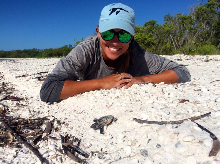
The effects of sand characteristics on the hatching success and clutch survival of Loggerhead sea turtles (2015-2016)
I completed my undergraduate thesis at Washington College in Chestertown, Maryland on data collected during a summer NOAA internship at the Rookery Bay National Estuarine Research Reserve in Naples, Florida. I collected sand samples taken from sea turtle nests and analyzed sand grain size, porosity, and total water holding capacity to determine if different sand characteristics affected the hatching success of sea turtle nests located in Southwest Florida.